Unfortunately, Sturry Parish Council disbanded its planning sub-committee a few months ago. As a result, SABORA has put together a response that we hope fairly represents the views of our local community. Please let us know what you think, either in the publicly viewable comments below, or by email at info@sabora.co.uk

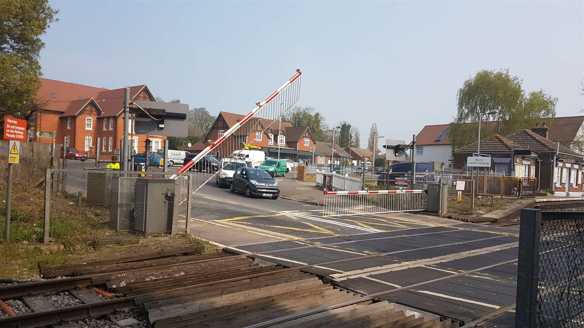
Extending the platforms at Sturry Station is welcomed in our response
Response to Canterbury District Draft Local Plan May 2024 from SABORA (Sturry and Broad Oak Residents’ Association)
This response focuses on the implications of the Draft Local Plan for Sturry Parish, considering the over-arching and district-wide policies in this context, and is not intended to cover every aspect of the draft plan.
Section 1 Planning Issues for Sturry
- Planning issues of high priority for Sturry Parish.
- Transport
- Road vehicle through traffic (safety, pollution and congestion)
- Public transport (cost, adequacy of provision)
- Footpaths and cycleways (safety, accessibility and convenience)
- Housing
- Scale of new housing targets (worries over impact of targets being met, worries over targets not being met – targets are wrong either way)
- Use of greenfield sites (concerns over loss of essential land uses)
- Village character (green gaps and village edges)
- Community facilities
- Balance of increasing population with provision of community facilities – (Land at Sturry etc.)
- Rectification of existing deficiencies
- Planning Issues of wider interest to the parish
- The Stour Valley (Stodmarsh and area of special landscape quality)
- Employment (avoiding the need for long-distance travel, diversity of opportunity)
- Sustainability (the cost/value balance of existing situation and proposals)
- Town centres (retail, cultural and commercial)
Section 2 Adequacy of Local Plan in Respect to Local Planning Issues Detailed report
Positive aspects of the Draft Plan
Transport
- We welcome and support the removal of the Canterbury Circulation Plan, the Eastern Movement Corridor. This includes the deletions of the site allocations at East Canterbury, which would have delivered a significant proportion of the corridor.
- We also welcome and support the revised Transport Strategy and its focus upon on achieving a realistic chance of modal shift through the clear focus upon improving bus provision
- We welcome the new transport strategy
- The removal of the Eastern Bypass will save significant greenfield areas and reduce the amount of embedded carbon required by the plan. For Sturry, the bypass would have drawn additional traffic onto the sections of the A291 and A28 feeding into the proposed Sturry Link Road.
- We welcome the support for an extension of the platforms at Sturry Station
Housing
- We welcome and support the shortening of the plan period and the corresponding real reduction in the housing target ie. a reduction in the annual target over the life of the plan but see comments below
- We are disappointed that this hasn’t gone further and that the reduction doesn’t transpire into any relief from the unwarranted burden of new development in this parish.
Environment
- We welcome and support the commitment to incorporate measures to deliver a minimum 20% biodiversity net gain. It’s important that this is given strong support by the Council as we have seen similar policy aspirations watered down elsewhere in Kent following lobbying from the development industry.
Negative Aspects of the Draft Local Plan
Transport – Road vehicle through traffic (safety, pollution and congestion)
- There is an urgent need to reduce private road traffic in the district if harmful emissions (PM2.5 and NO2) are to be reduced to World Health Organisation limits, but these plans do little to entice car drivers to change transport modes.
- In Sturry the A291 and A28 are very congested roads during times of peak traffic flow. Of the 1000s of vehicles which pass through Sturry the great majority are travelling to and from the north and east. These are areas for which huge housing and retail developments are planned, creating even more traffic through Sturry and Broad Oak.
- The proposed Link Road will encourage more traffic along the A291 and A28 into Sturry and Broad Oak.
- Part of the A291 in Broad Oak is already a national black road known for accidents.
- It should be noted that the recently reopened Sturry Road Park & Ride will have exacerbated this congestion, by drawing private vehicle drivers from outside the parish, through the village and on to the P&R.
- One adverse consequence of the congestion is the use of the main residential estate in Sturry as a cut through. This would be made worse by housing development on the Popes Lane field (R9) as traffic leaving this site will, at peak time, find it difficult to access the A291 via Popes Lane. The easier route to Sturry village, Fordwich, Hersden and towards Thanet will be via the estate roads onto the A28.
Transport, Spatial Planning and the Strategic Land Availability Assessment (SLAA)
- The SLAA does not consider sustainable transport; a major flaw in the Assessment’s consideration of site suitability, this allowing allocation of scattered sites without imposing any rationale towards district-wide sustainable transport and sufficiency of transport needs, contradicting CCC’s stated aims.
- More synchronisation is needed between the Transport Strategy and the SLAA.The Transport Strategy should insist that sustainable transport needs to be based on existing highways infrastructure, and the viability of public transport must be the deciding factor in the assessment of all land allocations and planning consents.
The purpose of the SLAA as it stands appears to be to allow the allocation of as many sites as possible in order to deliver what have been demonstrated to be unachievable housing targets. A review of the SLAA is urgently needed along with a realistic review of housing targets so that both work towards a genuinely sustainable spatial development strategy.
Transport – Public Transport
- The Draft Local Plan purports to be ‘bus-led’ but there is nothing in the short to medium term (up to 2035 – at least ten years away) that will benefit the residents of the area.
- Until recently new housing development along Shalloak Road and Sweechgate was serviced by our local bus services (no 7) and the sustainability of these developments in relation to public transport was one reason for granting planning consent. This bus service has now been discontinued, creating a dependency on cars and those without a car are stranded.
- No new development in these areas should be considered unless a long-term public transport service is restored. The proposed return of the bus to Broad Oak (to meet 2040 minimum service levels) is contingent on subsidy via CIL funding, but there are 100’s of Infrastructure projects in the Plan dependent upon the same, over-subscribed funding. This proposal is a vague aspiration rather than a genuinely costed and funded plan.
- There is no provision in the plans for electric car charging points within the parish – indeed, there is no strategy for this at all in the Draft Local Plan
Transport –Footpaths and cycleways (safety, accessibility and convenience)
- There are a number of new cycling routes in the area and some minor enhancements to existing routes but none of these appear to have any secured funding, nor is there a timetable for implementation. From a sustainable transport perspective, there are no new walking routes, nor any improvements to existing walking routes contradicting CCC’s stated aims.
- Whilst we welcome the improvements proposed, (if they can be funded), for cycling and walking routes to be effective in reducing car dependence they need to address the key essential/daily journeys to schools, work and local facilities.
- Priority for walking and cycling within this context needs to mean exactly what it says and routes within new and existing areas need to be direct, pleasant and safe. For this the transport and open space strategy need to be coordinated, especially with regard to the provision of green corridors.
Housing – Scale of new housing targets
SABORA wish to fully endorse the following responses to consultation on the draft Local Plan 2040
- Discussion paper and letter to Canterbury city Council of 21st May 2024 from ACRA
- the response of the Canterbury Association
- the response from CPRE
As set out within CPRE’s recent report “Building on our food security”: in the past 12 years England has lost over 14,000 hectares of Grade 1 and 2 agricultural land to development, the equivalent to the productive loss of around 250,000 tonnes of vegetables. It also appears that this figure is increasing, with nationally there being a 100-fold increase in 2022 from that built on in 2010. This loss cannot continue to be ignored which is why it remains pertinent that the selection of our local sites is at odds with NPPF paragraph 174(b).
As the Association of Canterbury Residents Associations have stated, “Canterbury City Council has taken a favourable view of redevelopment of a few brownfield sites in the district for partial residential use, Kingsmead being a recent example. However, there was no sign in 2019 or 2020 of the council thoroughly evaluating brownfield potential and revisiting housing supply site allocations on greenfield land accordingly, in order to comply with the revised NPPF. That should have been done, even if it would require a recasting of part of the Local Plan.”
- There are 224 new houses proposed for Sturry and Broad Oak (and 150 on the Westbere/Sturry border, R5, the Bread and Cheese Field) which are in addition to the already approved plans for 1050 in the 2017 plan.
- All but 12 are on greenfield sites around the edge of the village. This is in direct contradiction of the new administration’s stated preference for building on brownfield sites.
- The largest of these sites in Sturry and Broad Oak, R 9, in Popes Lane, proposes building on grade 2/3 arable land, and is a repeat of a proposal that has been turned down twice in the past. The LP states that building cannot take place until the Sturry Link Road is completed. This ever-increasing costly project has been delayed for some years and there is no sign of commencement (and essentially funding being available) from the yet to be built 630 homes adjacent to the Link Road. It seems pointless to add this project to the local plan at this stage.
- The proposed developments in the area in the draft Local Plan are R5(Westbere/Sturry) R6 (Hersden), R9 (Popes Lane), R10 (Paddocks), R14 (Goose Farm), R15 Shalloak Road, R16 (Mayton Lane) and R17 (Broad Oak Reservoir) are greenfield sites, except for R15 and the commercial part of R14. Most of these areas are classified as the Best and Most Versatile Land and create infilling in an already overburdened area with a lack of public open space.
- Three of the proposed sites would require car access because of the paucity of public transport and there is no indication that there will be a sustainable housing mix, or consideration for elderly accommodation.
- The proposed plan will continue the recent planning history allowing fragmented in-filling of small sites, which will not make for a cohesive community.
Housing – Residential Service Charges.
In recent years, local authorities have moved towards a refusal to adopt residential roads and public open spaces. The full cost now has to be carried by residents. In rural areas this effectively creates a third level of taxation (council tax, the parish precept and the residential service charge). This is discriminatory and adds to the unaffordability of new housing. (At the moment the cost of maintaining parish-owned open space is partially levied through council tax and refunded to parishes via the Concurrent Function Funding and this reduces the problem of double taxation.
- No equivalent funding is available to residents who are directly paying for public open space as part of their service charge.
- The Local Plan proposes to address this problem through local authority adoption of open space but only in developments of over 500 houses. This means that thousands of new householders will continue to suffer financial discrimination.
- All PUBLIC amenities (roads and open space) need to be adopted by local authorities with developers paying a commuted sum for maintenance.
Housing – Village character (green gaps and village edges)
- R9 (Land North of Popes Lane) plans a new development of 110 houses, extending the village envelope and coming very close to the green gap between Sturry and Broad Oak, therefore development of the site would naturally lead to the coalescence of these settlements.
- Planning permission has been previously refused and an appeal was dismissed due to the proposed development’s impact on the road network and highway safety. It also abuts ancient woodland and is known to be habitat for bats, dormice, newts and slow worms.
- The cumulative effect of all proposed developments in the Sturry and Broad Oak area, in addition to those already passed, creates a total change in character of Sturry.
- Although defined by the LP as a ‘Service Centre’, both Sturry and Broad Oak are villages with a long history. Sturry has numerous ancient, listed buildings and the centre is registered as a Conservation Area
- Extending the settled area with developments that owe more to manufacturer’s templates rather than reflecting the local vernacular will diminish the built character and, as a consequence, the quality of life for its community.
- In January 2021, Robert Jenrick, proposed changes to the National Planning Policy Framework to place greater emphasis on beauty and place-making, and to ensure that all new streets are lined with trees. This is not being followed.
- In addition, the 190-page ‘Living with Beauty’ report published in January 2020 proposed a new development and planning framework, with 3 principle goals – to ask for beauty, refuse ugliness and promote stewardship. We have not seen evidence of this in the draft LP.
We are particularly concerned with respect to the cumulative impact of all proposed developments across the villages of Sturry, Broad Oak, Westbere, Hersden, and Fordwich. Many of the proposed developments appear to be driven by the need to fund the Sturry relief road, a project estimated to cost £41.6 million. There is widespread scepticism about the effectiveness of this road, as it will ultimately feed back into the bottleneck of the A28. This could render the relief road ineffective in alleviating traffic congestion, thereby failing to justify the substantial investment – and with it all the sacrifices and breaches of planning policies imposed on this parish in order to deliver it.
Community facilities.
Evidence of need.
In 2017 Sturry Parish Council (which at that time included Hersden) completed a facilities audit. Schools and medical facilities were outside the scope of this audit but pre-school facilities, community halls, sports and open space of all types were included. This document had been submitted to Canterbury City Council on a number of occasions as part of the parish’s response to new development proposals.
- On no occasion have the findings been taken into account when new development proposals have been considered. Briefly, the audit revealed serious deficits in open space provision of all kinds and that existing provision of community halls would not cope with the proposed increase in population. For open space these findings are factual, evidenced and take Canterbury City Council’s own standards as the benchmark.
Canterbury City Council has commissioned its own assessments of open space and playing pitch provision but these do not accurately report the deficiencies in Sturry Parish – see comments below
Policies for the provision of community facilities in Sturry Parish
- Existing policy SP3 for Site 2 Sturry and Broad Oak requires “community facilities to meet local needs” SP3 has been carried forward into the new draft plan as CF2
- Local Plan policies provide for the city council’s open space standards to be met for all new residential development, therefore the major residential development of 1050 homes proposed for Site 1 and 2 (in the draft Local Plan 2040 this is included in policy CF1) should, at the very least, have met its own needs for open space and a village hall. Instead, this site has been allowed to under-provide. This has come about in three ways:
- Waiver of the developer’s obligations
- Acceptance of contributions for off-site which cannot be delivered within a reasonable distance of the development (according to Canterbury’s distance thresholds)
- Open spaces not being fit for purpose and will foreseeably be underused, e.g. unsafe due to lack of informal surveillance, being used for SUDS schemes and not available for physical access of any kind. All leading to very low sustainability in terms of the cost benefit balance. As the maintenance of open space would rest with management companies, over which no one has any control, defaulting on adequate maintenance is a very high risk and would lead to further loss of utility and environmental quality.
- It follows that major new development in the parish will therefore exacerbate existing deficiencies, and both the Parish’s Facilities Audit and the City Council’s assessments of the current situation must be amended to fully reflect the foreseeable impact of approved plans on the sufficiency of provision. These two documents inform the Open Space Strategy and the Playing Pitch Strategy and these, in turn, inform the Local Plan and its policies.
- At the current time the City Council’s Open Space Assessment Report 2022 and the Canterbury District Playing Pitch Strategy Assessment 2020 do not even fully reflect existing deficiencies within the parish and fail to meet the NPPF requirement. The National Planning Policy Framework (NPPF) requires an accurate, honest and up to date assessment of the existing situation.
- There has been a misuse/misunderstanding of the ANGST Standards for semi-natural space –it assumes that large sites at 2 km distance or more can be substituted for local accessible provision.
- The quantity of local provision of open space is compared with existing district quantities rather than any accepted standards – the comparison gives no account of the adequacy of local provision.
- In the quantitative comparison, provision for children and young people and outdoor sport provision has been omitted. (OSAR 2022 p80)
- In arriving at the conclusion that Sturry Parish is not, on average, deficient in open space, the large area of semi-natural open space with a 2km catchment (Blean and Thornden Woods) has been counted, therefore accepted as a substitute for other kinds of open space.
- Blean and Thornden Woods should not be counted as public open space– public open space is defined in the Town and Country Planning Act (1990) as being “any land laid out as a public garden, or used for the purposes of public recreation, or land which is a disused burial ground”. These woodlands are privately owned and are not open to the public. Large areas of the woodland are now fenced off as part of a rewilding project and access is only along designated public rights of way.
- The Open Space Assessment Report acknowledges that there are no playing pitches available for community use in the parish. However, the Canterbury District Playing Pitch Strategy Assessment 2020 includes pitches within local schools in its assessment of pitches available to residents, even though these pitches are not available for community use.
- The single full-size pitch recorded in the assessment is leased from a private landowner by a local club and this is also not available for other community use. This Assessment also has misleading information on the possibility of increasing the capacity of this pitch through pitch improvements.
- In relation to the provision of sports pitches and the adequacy of provision the Playing Pitch Strategy takes priority in the Draft Local Plan, meaning that draft policies affecting local provision are based on unsound data.
- The Playing Pitch Strategy is a quantitatively data-based document which takes no account of the need for outdoor sports facilities to be accessible therefore acknowledges no deficiency in playing pitches in the parish.
- The Strategy averages out provision and demand across the district such that if there is provision somewhere, however far away, it is considered adequate. This is in contradiction of one of the Strategy’s key objectives, which is, “To ensure that there are enough facilities in the right place to meet current and projected future demand.”
- Community Centres. According to policy CF1 Site 2 in Land in Sturry and Broad Oak will provide “community facilities to meet local needs”.. CF1 Site 2 should have provided an additional centre or made a significant contribution towards providing additional facilities off site.
- The developer for Land at Sturry offered a site for a new community centre situated between arms of the proposed Link Road (practically a traffic island) with very limited safe access, a former quarry site of very uneven and unmapped contours and no assessment of ground stability.
- Site CF1 Site 2 is adjacent to the Former Homersham Pit archaeological SSSI where the presence of important Palaeolithic artefacts is very likely. A more unsuitable site for a community would be hard to find and could not be accepted. There has been no other secured contribution to a community centre from this site.
- Policy SS3 – Development Strategy for the District states that for Sturry and Broad Oak “The provision of new community facilities and services, business space and tourism facilities outside of settlement boundaries will be supported provided such development is proportionate in scale to the relevant settlement and the need for the development outweighs any harm.”
8. In the 2020 call for sites Sturry Parish council submitted the field north of Popes Lane for a community centre and sports fields (see comments on the Playing Pitch Assessment). This submission conflicted with another submission for the same site for housing. In allocating this site for housing the City Council has failed:
- to support new provision of much needed community facilities – where there is no other suitable location within walking distance of residents,
- to respect the wishes of residents that there is no more housing proposed for the parish without rectification of open space and community space,
- to appreciate that land allocations in the Local Plan should be instrumental in positively driving necessary land use,
- to acknowledge that housing on this site is dependent on the completion of the Sturry Link Road and will not go ahead if plans for the Link Road are abandoned,
- If a contribution for the Link Road is taken from this site, as anticipated, then this will drain developer funding that should have contributed to community facilities, further deepening the existing deficits.
Environment – The Stour Valley (Stodmarsh and area of special landscape quality)
The Stour valley and Sarre Penn will be at risk from surface water run-off from new developments which are being planned to drain into these waterways. The area of land required for “sustainable urban drainage” is very significant and development proposals have only maintained housing densities by allowing these drainage schemes to encroach into public open space, effectively making them unusable for any kind of recreational use.
- The ongoing maintenance cost of SUDS schemes, which will need periodic dredging and clearance of naturalising vegetation is very high and the water levels fluctuate too dramatically to provide stable terrestrial or aquatic habitats.
- The long-term sustainability of SUDS schemes is unproven and will depend on our future ability to finance their effective maintenance.
- Failure is inevitable at some point and both the frequency and severity of flood events in the river valley will be the consequence.
- New development should not be allowed within the river catchment areas.
Environment – Sewage
- Sewage Treatment is a second major concern for the River Stour and the Stodmarsh Nature Reserve. The lack of capacity in local sewage treatment works means that untreated or partially treated sewage will have to be transported from new residential areas.
- The additional cost involved has to be borne by residents and, due to the refusal of Canterbury City Council to adopt open space and the refusal of Kent County Council to adopt most estate roads, service charges are already financially crippling.
- The transport of sewage by lorry is the least sustainable option and nowhere do we see an admission of the additional carbon footprint of these journeys. There should be no more development in the Stour Catchment area until efficient piped and centralised sewage treatment is available ( Sturry road expansion not planned until 2030)
Environment – Water
Broad Oak RESERVOIR (R17) Infrastructure planning concerns: the reservoir is proposed in both the WRSE – (in full) and South East Water plans, currently under consultation, to help meet the requirements for the projected household growth of the southeasternmost area of the region. Many agree that the projections of the numbers of households whose needs they are intending to meet are overstated. Current targets for household growth are known to be flawed, as representations explain elsewhere and, aggregated across the wider southeast region, the regional and individual water company projections of need are vastly in excess of the homes likely to be delivered.
- The site safeguarded for the reservoir has developed into a particularly diverse local habitat. While the intended commitment to improving green infrastructure is to be applauded, delivering a sustainable genuine net gain in biodiversity with all the promised recreational opportunities will be an extraordinarily challenging task.
- Hydrological concerns: the reservoir, situated in the Sarre Penn valley, will need to be supplemented by water pumped from the Stour. It is common local knowledge that the Sarre Penn stream frequently dries to a series of disconnected pools in summer, and that the winter flow of the Stour (to which the Sarre Penn is a tributary) is in long term decline, limiting the options for filling any reservoir at this spot.
CCC could find itself left with the worst of all options: high housing targets based on the assurance of water supply from a reservoir that may never fully function, lacking the available water to fill it and failing to deliver the recreational and biodiversity gains that were promised
Employment (avoiding the need for long-distance travel, diversity of opportunity)
The development of employment opportunities has focussed on Canterbury’s tourism and universities. The universities are downsizing due to financial difficulties, tourism hasn’t fully recovered from the COVID epidemic and is not likely to expand further. There is an urgent need to diversify the local economy so there is more local primary employment and reverse the trend towards the district becoming a predominantly commuter area.
- Sustainability (the cost/value balance of existing situation and proposals)
- Town centres (retail, cultural and commercial)
Leave a Reply